print


09.12.2016.

Beside new functionalities, from December 2016 the Navigation Bulletin is available in German and French language.

Navigational Bulletin

After completion of the period of functional testing, the Directorate for Inland Waterways has published new contents in electronic Navigational Bulletin, as the fairway information service, providing up-to-date dynamic information on waterways in the Republic of Serbia, where international and interstate navigation regimes are applicable (Danube, Sava and Tisza).

New contents available in Navigational Bulletin are: forecast of available depths on berths based on available information on water level forecast, dynamic indication of available fairway depth on critical sectors depending on predefined boundary values, dynamic indication of available vertical clearences at bridges depending on predefined boundary values, as well as information on status and working plan of the lock on the Tisza River.

Availability of Locks

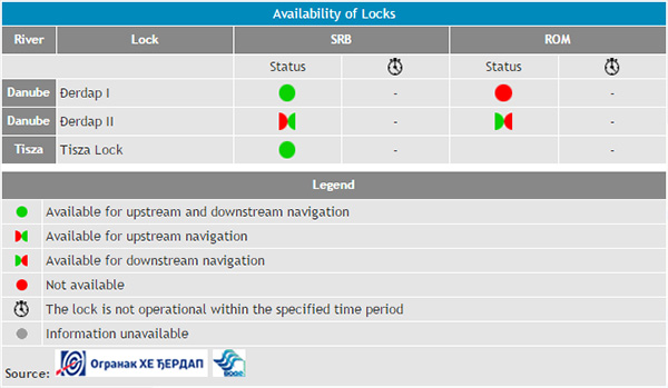
From earlier, the following information are available at the Navigationla Bulletin: water level and water level forecast, wind speed and direction, notices to skippers, system of waterway marking, available fairway depths on critical sectors for navigation, forecast of available depths on critical sectors for navigation, available vertical clearances at bridges, forecast of available vertical clearances at bridges, status and working plan of locks on the Danube River, availability of River Information Services, as well as contact information of relevant authorities in the Republic of Serbia. Beside Serbian and English language, the Navigational Bulletin is now available in German and French language as well.


Nazad


Keywords:
navigational, bulletin


Related news:

14.10.2009 Serbia and Croatia Signed Bilateral Agreement on Navigation and IWW
05.10.2009 Plovput Continues to Modernize IWW Marking System
13.09.2018 Beginning of the works execution under the project "River Training and Dredging Works on critical sectors on the Danube River"
30.12.2020 New Electronic Navigational Charts for the Sava River
07.11.2018 Study visit of the cadets of the Military Academy of the University of Defence
04.12.2018 Plovput published Navigational Chart of the Sava River adjusted for printing in A4 format
04.12.2018 New Electronic Navigational Charts for the Sava River
06.12.2018 New layouts of the critical sectors on the Sava River
13.12.2018 New Electronic Navigational Charts for the Tisza River
13.12.2018 Plovput published Navigational Chart of the Tisza River
27.12.2018 Plovput published Navigational Chart of the Danube River
24.12.2018 New Electronic Navigational Charts for the Danube River
14.06.2019 New edition - Atlas of Berths for Danube, Sava and Tisza
17.06.2019 Plovput published the new edition of the Danube River Navigational Char
04.07.2019 Changes of available dimensions and dislocation of the fairway on the critical sector Futog
28.11.2019 The new layout of the critical sector Futog
30.12.2019 Plovput published Navigational Chart of the Sava River
30.12.2019 Plovput published Navigational Chart of the Tisza River
30.12.2019 New Electronic Navigational Charts for the Tisza River
30.12.2019 New Electronic Navigational Charts for the Sava River
30.12.2020 Plovput published the new edition of the Danube River Navigational Chart
30.12.2020 Plovput published Navigational Chart of the Sava River
30.12.2020 New Electronic Navigational Charts for the Danube River
30.12.2016 ENC for the Danube River in Inland ECDIS standard 2.3
23.11.2015 New Electronic Navigational Charts for the Danube River
01.03.2016 Plovput published new Electronic Navigational Charts for the Sava River
22.03.2016 Plovput published second edition of navigational chart for the Danube River
05.07.2016 Plovput published new Electronic Navigational Charts for the Tisza River
05.07.2016 Plovput published Navigational Chart for the Tisza River adjusted for printing
03.08.2016 Plovput published new situational plans of critical sectors for navigation on the Sava River
13.09.2016 At critical sector Futog fairway dislocated and narrowed
17.09.2016 New Electronic Navigational Charts for the Sava River
09.12.2016 New functionality of Navigational Bulletin available to waterway users
14.12.2016 New Electronic Navigational Charts for the Tisza River
06.08.2018 Changes of available dimensions and dislocation of the fairway on the critical sector Futog
13.02.2017 Plovput published the third edition of Navigational Chart for the Danube River
12.06.2017 Changes of available dimensions and dislocation of the fairway on the critical sector Futog
14.07.2017 Plovput published Navigational Chart of the Sava River adjusted for printing
14.07.2017 New Electronic Navigational Charts for the Sava River
03.11.2017 With the sediment dredging navigation conditions at critical sector Kamičak on the Sava River enhanced
21.11.2017 Plovput published new Electronic Navigational Charts for the Tisza River
21.11.2017 The second edition of Electronic Navigational Charts for the Tisza River adjusted for printing
25.12.2017 Relocation of the fairway at the Futog critical sector
22.05.2018 Changes of available dimensions and dislocation of the fairway on the critical sector Futog

RSSPlovput FacebookPlovput TwitterPlovput InstagramPlovput Youtube


download documents

Informer

Photo Gallery

newsletter


Stakeholders' Forum

Danube Glossary 2019


Danube Stream