print


14.07.2017.

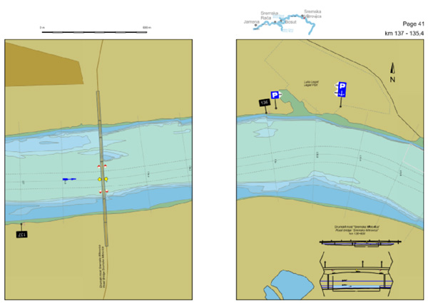
The third edition of the Navigational Chart of the Sava River available at the internet presentation of Plovput.

Plovidbena karta reke Save


Navigational Chart of the Sava River (km 210.8 – km 0.00) contains up-to-date information on the position of the fairway, waterway marking system, critical sectors for navigation, distance marks at 200m on fairway axes, cross-sections at 200m, berths, infrastructure objects on the waterway (bridges, river training structures), main settlements along the Sava River, gauging stations and characteristic navigation levels at the time of publication, as well as contact information of authorities in the Republic of Serbia relevant for navigation on inland waterways.

The most important changes in the third edition of the Chart are information on the construction site of the new bridge on the Sava River upstream of the Kolubara confluence, including location of the temporary bridge and adjusted waterway marking system, as well as information on available depth with reference to low navigational level on the stretch from rkm 210.8 to rkm 59.0, based on the results of the hydrographic survey performed in the period May-June 2017.

Plovidbena karta reke Save

Navigational Chart adjusted for printing in A4, can be downloaded from paper navigational charts page, in PDF, free of charge.


Nazad


Keywords:
sava, navigational, chart


Related news:

12.02.2010 Plovput at GIS Forum Danube Held in Vienna
02.10.2009 Plovput Finished the Sava River Marking Campaign for 2009
14.10.2009 Serbia and Croatia Signed Bilateral Agreement on Navigation and IWW
05.10.2009 Plovput Continues to Modernize IWW Marking System
13.11.2009 Plovput at the Meeting of Bilateral Romanian-Serbian Working Group for Electronic Navigation Charts
06.08.2018 Changes of available dimensions and dislocation of the fairway on the critical sector Futog
30.12.2020 New Electronic Navigational Charts for the Sava River
07.11.2018 Study visit of the cadets of the Military Academy of the University of Defence
04.12.2018 Plovput published Navigational Chart of the Sava River adjusted for printing in A4 format
04.12.2018 New Electronic Navigational Charts for the Sava River
06.12.2018 New layouts of the critical sectors on the Sava River
13.12.2018 New Electronic Navigational Charts for the Tisza River
13.12.2018 Plovput published Navigational Chart of the Tisza River
27.12.2018 Plovput published Navigational Chart of the Danube River
24.12.2018 New Electronic Navigational Charts for the Danube River
14.06.2019 New edition - Atlas of Berths for Danube, Sava and Tisza
17.06.2019 Plovput published the new edition of the Danube River Navigational Char
04.07.2019 Changes of available dimensions and dislocation of the fairway on the critical sector Futog
08.11.2019 Study visit of students of the Faculty of Transport
28.11.2019 The new layout of the critical sector Futog
30.12.2019 Plovput published Navigational Chart of the Sava River
30.12.2019 Plovput published Navigational Chart of the Tisza River
30.12.2019 New Electronic Navigational Charts for the Tisza River
30.12.2019 New Electronic Navigational Charts for the Sava River
30.12.2020 Plovput published the new edition of the Danube River Navigational Chart
30.12.2020 Plovput published Navigational Chart of the Sava River
30.12.2020 New Electronic Navigational Charts for the Danube River
14.12.2016 New Electronic Navigational Charts for the Tisza River
23.11.2015 New Electronic Navigational Charts for the Danube River
01.03.2016 Plovput published new Electronic Navigational Charts for the Sava River
22.03.2016 Plovput published second edition of navigational chart for the Danube River
05.07.2016 Plovput published new Electronic Navigational Charts for the Tisza River
05.07.2016 Plovput published Navigational Chart for the Tisza River adjusted for printing
03.08.2016 Plovput published new situational plans of critical sectors for navigation on the Sava River
13.09.2016 At critical sector Futog fairway dislocated and narrowed
17.09.2016 New Electronic Navigational Charts for the Sava River
30.09.2016 5.7 million tons of cargo transported by waterways in the first 6 months of 2016
09.12.2016 New functionality of Navigational Bulletin available to waterway users
22.05.2018 Changes of available dimensions and dislocation of the fairway on the critical sector Futog
30.12.2016 ENC for the Danube River in Inland ECDIS standard 2.3
13.02.2017 Plovput published the third edition of Navigational Chart for the Danube River
12.06.2017 Changes of available dimensions and dislocation of the fairway on the critical sector Futog
14.06.2017 Waterway marking system on the construction site of new bridge on the Sava River updated
14.07.2017 Plovput published Navigational Chart of the Sava River adjusted for printing
14.07.2017 New Electronic Navigational Charts for the Sava River
03.11.2017 With the sediment dredging navigation conditions at critical sector Kamičak on the Sava River enhanced
21.11.2017 Plovput published new Electronic Navigational Charts for the Tisza River
21.11.2017 The second edition of Electronic Navigational Charts for the Tisza River adjusted for printing
25.12.2017 Relocation of the fairway at the Futog critical sector

RSSPlovput FacebookPlovput TwitterPlovput InstagramPlovput Youtube


download documents

Informer

Photo Gallery

newsletter


Stakeholders' Forum

Danube Glossary 2019


Danube Stream